
Marine Surveillance
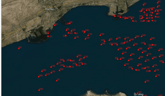
The steady rise of human activity at sea, which is inherently dynamic, has led to an ever-increasing demand for effective marine surveillance. Satellite based data can be a valuable resource to monitor marine activity, challenging in terms of both scope and scale. Vessel position and track information can be overlaid on satellite imagery to obtain a complete and true picture of maritime activity, including the existence and locations of vessels not reporting themselves.
The key features of this service are as follows:
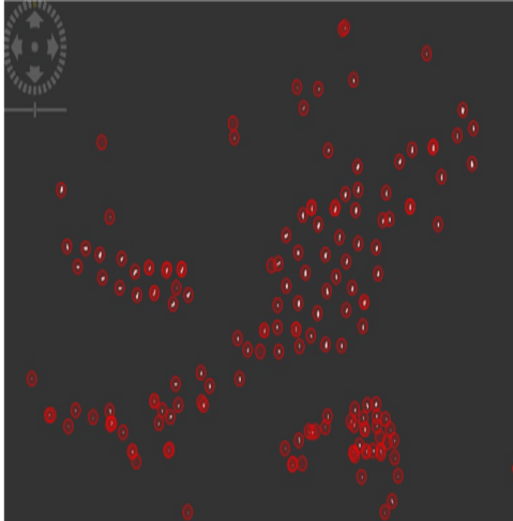
- Vessels are located as bright spots on SAR imagery
- Vessel position, length & width is assessed
- Vessel heading and speed may be determinable based on observed SAR data
- Radar data may be cross-referenced with other data (AIS) to determine nature of activity & compliance with regulations
How are the services provided?
- Site locations & ports are specified by the client, detection of ships & marine objects are based on quantitative analysis.
- Results include length, width & location at the time of detection. The results are provided in a report with tabulated data.
- Geo-referenced data can also be provided in the form of GeoTIFFs or KMZ files or as per requirement.
- Radar data can be cross-referenced with other sources of data (AIS) as per requirements of the customer.
Satsense Solutions Marine Vessel Detection Services provide a highly effective and reliable solution for marine surveillance:
- Marine vessels are detected irrespective of data being transmitted via tracking systems (such as AIS) onboard the vessel, i.e. detection is based on non-cooperative system of surveillance
- Results are independent of cloud, weather and daylight conditions
- Larger areas & remote locations can easily be subjected to surveillance
- Results can be obtained at regular intervals and cross-referenced with other data (AIS)
Satsense Solutions Marine Vessel Detection Services can be used by a variety of businesses and agencies, such as:
- Marine vessel operators and insurance companies to assess marine & port risk accumulation
- Port authorities to locate vessels in the harbor and cross-check reported position data
- Coast guards to monitoring security incidents in remote areas or under poor weather conditions
- Fisheries departments and boards to monitor illegal fishing activities either in prohibited locations or during prohibited times
- Customs authorities to maintain oversight on goods transported by sea and detect possible illegal activity like ship-to-ship transfers
- International maritime organizations to monitor marine pollution, like illegal ship discharges