
Pipelines are the safest, most efficient and widely used mode of transporting hydrocarbons. The safety and integrity of hydrocarbon pipelines is paramount as structural damages, leaks or accidents can be costly, both from an environment and human life perspective, but also from an operational perspective due to pipeline outages. Regular monitoring and maintenance increase the longevity of the pipeline while reducing risks. Pipeline operators spend significant resources to ensure the smooth and efficient operations of the network.
Satsense Solutions uses cutting edge satellite remote sensing technology and geospatial analytics to provide a suite of services to efficiently monitor the integrity of hydrocarbon pipelines, while enhancing network safety and mitigating risks.
What are these services?
Geohazard Impact Assessment
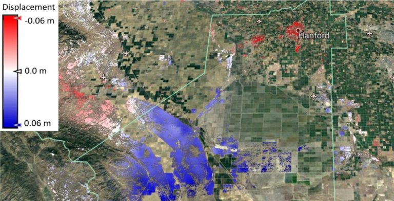
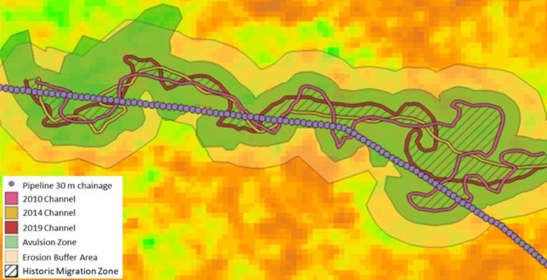
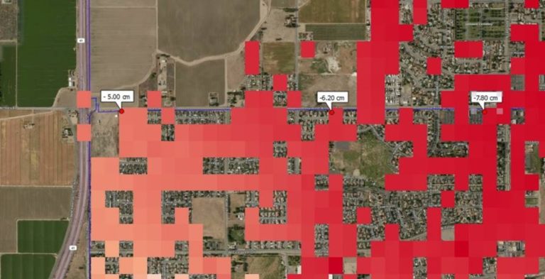
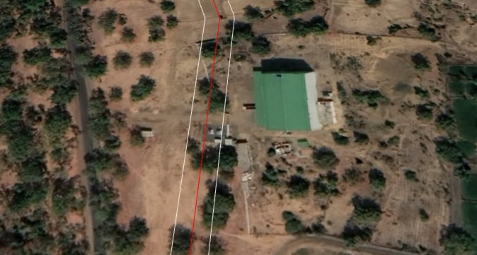
Pipelines are susceptible to geohazards due to their long and liner paths, varying terrains they pass through and unpredictable environmental factors caused by climate change. Beyond certain thresholds of stress and exposure, hydrocarbon pipelines are at risk of damage and failure. Over time it has become increasingly important for pipeline operators to assess geohazard impacts and take proactive risk mitigating action. Geotechnical & Seismic hazards relate to ground disturbances caused by earthquakes, landslides, mining and construction and can lead to pipeline displacement as well as produce additional longitudinal tensile and compression loads on the network. While Hydrotechnical hazards relate to river channel migration, flooding and shifting sands and can expose the pipeline, thus making it more prone to damage and corrosion. Using Synthetic Aperture Radar (SAR) and multiple spectrum imagery, this service measures ground disturbances over a period of time, up to millimetre (mm) in accuracy. In addition, channel migration zones, erosion buffers and flood avulsion zones are mapped to safeguard against damages to the pipeline. Geospatial analytics is subsequently used to ascertain the pipeline’s exposure levels, chainage location and severity of the geohazard.
High Consequence Areas Classification
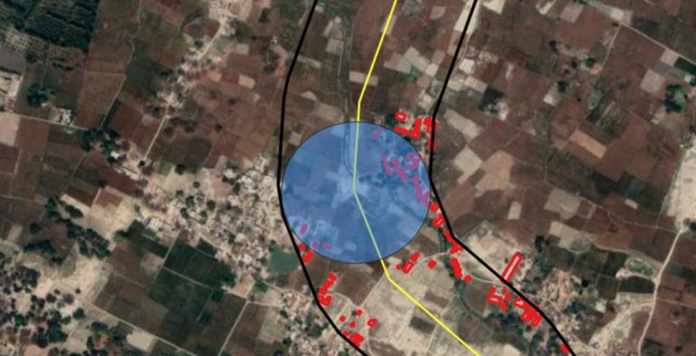
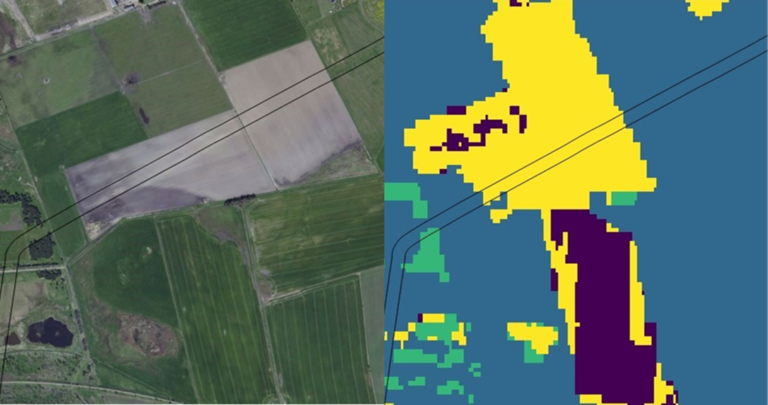
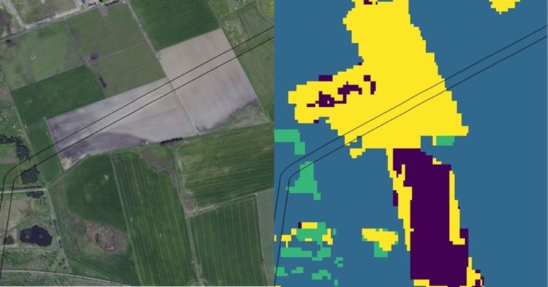
High Consequence Areas (HCAs) are regions around pipeline segments that have high residential density and/or deemed to be environmentally sensitive. The extent of an HCA is determined by the potential impact circle (PIC), which is an estimate of the area that would be thermally impacted by a pipeline rupture and hydrocarbon ignition. Regulations require pipeline operators to classify HCAs as well as have additional safety features in these areas. This service uses satellite remote sensed data to ascertain residential density and environmentally sensitive areas, followed by using geospatial analytics, machine learning tools and algorithms to classify HCAs around the pipeline.
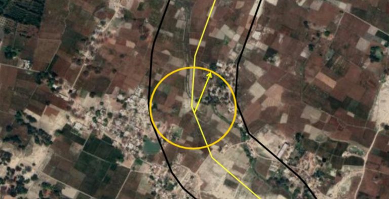
Right of Way Monitoring
Right of Way (ROW) or Right of Use (ROU) is a buffer zone generally extending 10 metres or more on either side of the pipeline. This area is kept free of vegetation and man-made structures in order to avoid pipeline damage or hinder access to the network for routine patrolling, repairs and maintenance. Satellite remote sensing data combined with machine learning tools and algorithms are used to detect ROW or ROU breaches. Pipeline operators are informed of relevant land cover changes, encroachments and obstructions, thus enabling operators to deploy resources efficiently by carrying out targeted on-ground inspection of high-risk locations for appropriate remediation and repair.

Contact Us
Disclaimer: Satellite remotely sensed data are generally recorded under changing environmental conditions, which might impact the accuracy of output data. Although results are based on well-established methods and tools are thoroughly validated for accuracy, remotely sensed data are subject to natural variations of the atmosphere, local conditions etc., therefore Satsense Solutions Limited cannot take any responsibility caused by the usage and interpretation of remote sensing products. As with all measuring tools / systems, calibration based on in-situ data is recommended.