Mapping key minerals to achieve more efficient mineral exploration
Detecting Acid Mine Drainage and Tailing Contamination
Measuring mine subsidence (in mm)
Monitoring mine rehabilitation of the landscape post mining
Mining provides raw materials, minerals and metals critical to the global economy and lays the foundations for modern living, innovation and engineering achievements. The industry is essential to the production of goods, services and infrastructure that improve the quality of our lives. However, mining operations usually have negative environmental impacts, both during the mining activity and after a mine has closed. Hence it is important to harness innovative technology to make mining more environmentally sustainable.
Satsense Solutions uses cutting edge satellite remote sensing technology and geospatial analytics to provide a suite of solutions to make mine exploration and management more efficient, reduce environmental impacts and ensure safe closure and rehabilitation of mines.
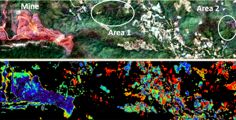
Hyperspectral or multispectral satellite remote sensing data is used to map the chemical characteristics of minerals and rocks and to identify lithologies, structures (faults, folds, fractures) and surface mineralogy. Key minerals (known as indicator or pathfinder minerals) provide clues to the possible presence and location of specific types of minerals and can be used to effectively narrow down the search area for different types of ore deposits. This solution provides a great opportunity to survey large areas and map mineral assemblages or individual mineral groups in order to achieve more efficient mineral exploration.
Rock outcrop seen in true colour (left), ferric oxide abundance seen in red (right)
Mineral Exploration area seen in true colour (top), pathfinder mineral gossan abundance seen in red (bottom)
Rock outcrop seen in true colour (left), ferric oxide abundance seen in red (right)
Mineral Exploration area seen in true colour (top), pathfinder mineral gossan abundance seen in red (bottom)
Acid Mine Drainage and Tailing Detection
Large number of mines suffer from Acid Mine Drainage (AMD) and Mine Tailing (MT) contamination. Once sulfur-bearing minerals are exposed to oxygen and the surface environment, acid generation is very difficult to contain or stop and can continue for hundreds of years until such minerals are exhausted. In addition, finely ground residue from ore extraction can poison downstream waters, in many cases to the point where nothing other than microbes can survive. Spectral analyses using satellite remote sensing can be used to detect AMD and MT contamination in water bodies, providing mine operators with actionable information into the potential source and level of contamination and thereby allowing for appropriate remediation actions to be taken.
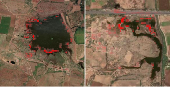
Tailing contamination in water bodies seen in red
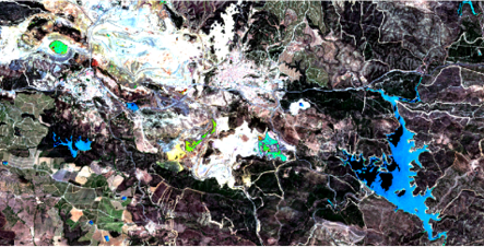
AMD in water bodies close to the mine seen in green, whereas clean water seen in blue
Tailing contamination in water bodies seen in red
AMD in water bodies close to the mine seen in green, whereas clean water seen in blue
Mine Subsidence Measurement
Mine Subsidence occurs as a result of settlement of the earth’s crust due to removal of subsurface solids or underground excavation. Mining-induced subsidence is almost always localised to the surface above the mined area, plus a surrounding buffer area. The vertical magnitude of subsidence can cause damage to the natural environment, buildings and infrastructure. Mine subsidence can be successfully managed through careful planning, accurate measurements, regular monitoring, taking preventive actions and carrying out necessary repairs. Satellite SAR data and differential Interferometric SAR (InSAR) processing techniques are used to measure subsidence (in mm) covering large areas over time.
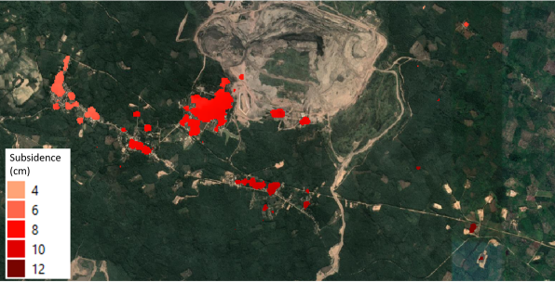
Mining induced subsidence measured near a coal mine over a period of two years.
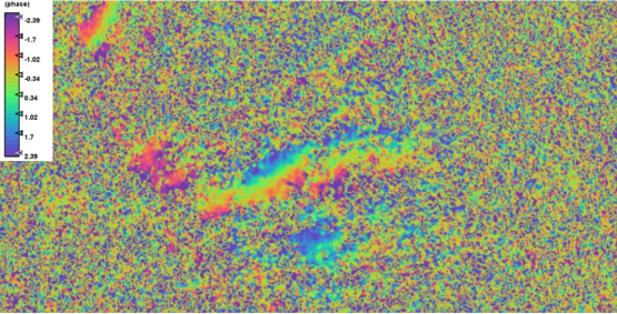
Phase difference (interferogram) used to measure subsidence over time.
Mining induced subsidence measured near a coal mine over a period of two years.
Phase difference (interferogram) used to measure subsidence over time.
Mine Rehabilitation Monitoring
Mine rehabilitation is the restoration of the landscape to the intended post-mining land-use once mining operations has ended. Mine closure and rehabilitation ultimately define the mine’s long-term impact on and contribution to an area’s social, economic and environmental development, and therefore need to be carefully planned. Satellite remote sensing can play a vital role in ensuring mine rehabilitation milestones are being met through monitoring vegetation regeneration, measuring landform stability and detecting acid mine drainage and mine tailing water contamination.
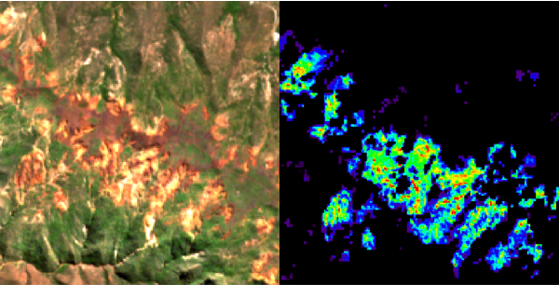
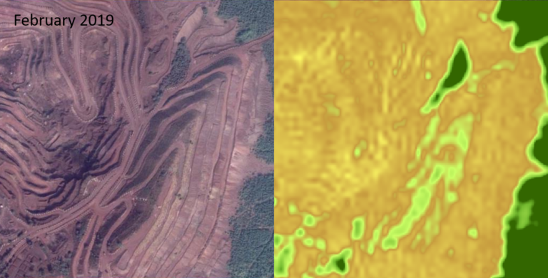
Monitoring vegetation growth for securing overburden dumps at the time of mine closure
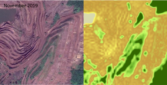
Monitoring vegetation growth for securing overburden dumps approximately a year after mine closure
Monitoring vegetation growth for securing overburden dumps at the time of mine closure
Monitoring vegetation growth for securing overburden dumps approximately a year after mine closure
Contact Us
Disclaimer: Satellite remotely sensed data are generally recorded under changing environmental conditions, which might impact the accuracy of output data. Although results are based on well-established methods and tools are thoroughly validated for accuracy, remotely sensed data are subject to natural variations of the atmosphere, local conditions etc., therefore Satsense Solutions Limited cannot take any responsibility caused by the usage and interpretation of remote sensing products. As with all measuring tools / systems, calibration based on in-situ data is recommended.