Global seafood consumption has doubled in the last 50 years, due to population and income growths, and is expected to grow even further in the coming years. With the global catch of wild fish being stagnant due to unsustainable practices and climate change threatening the health of entire aquatic ecosystems, experts say virtually all new seafood will have to be farmed. However, aquaculture’s ‘blue revolution’ to meet the world’s growing food demands faces significant challenges, mainly around sustainability and innovation.
Satsense Solutions uses cutting edge satellite remote sensing technology and geospatial analytics to provide a suite of services that enable aquaculture practices to be more environmentally friendly while improving the overall efficiency of farming practices.
What are these services?
Farm Site Assessment
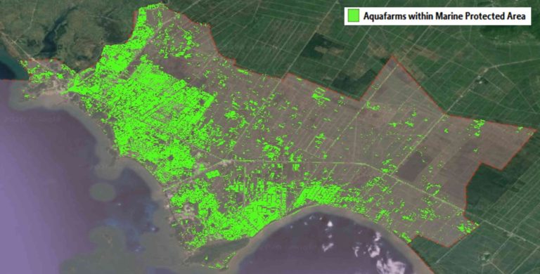
- Farm location is monitored to assess if it is situated in protected ecosystems, environmentally sensitive zones and in or near critical habitats for endangered species. Such farms are required to adhere to more stringent standards.
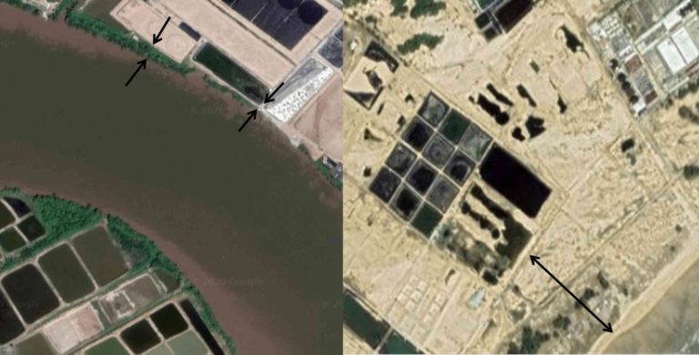
- Farm features such as coastal barriers, riparian buffers and corridors between farm boundaries are measured and assessment for type of land cover (vegetation, barren, etc.). Maintaining minimum prescribed widths for ecological barriers provide enhanced disease and predator control.
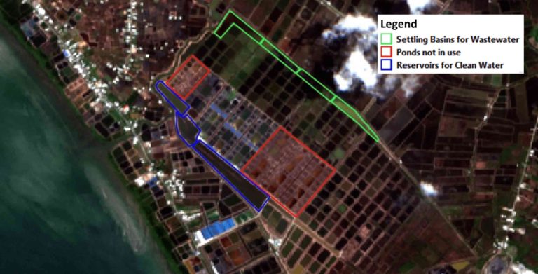
- Farm practices such as the use of settling basins and/or public waterways are assessed to ensure responsible handling and disposal of sludge and sediments. This provides great oversight and can also be used to prescribe best industry practices.
Water Quality Assessment
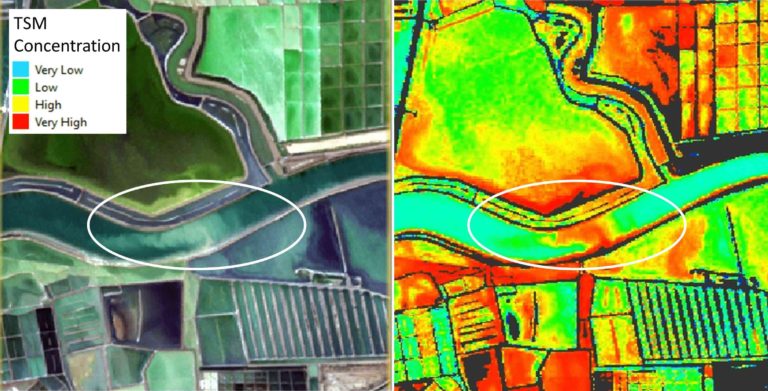
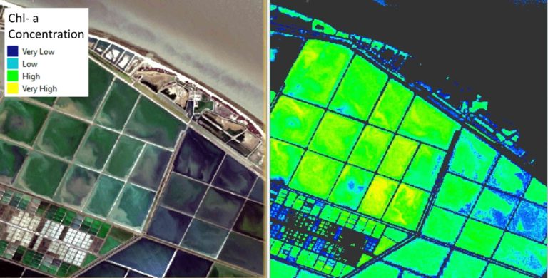
Water quality is the most important factor affecting fish health and thus managing an optimum range (varying across different species) can help farms increase yield and improve productivity. In addition, monitoring and reducing effluence loads can help diminish adverse ecological impacts on receiving waters and thereby improving sustainability of farming operations. This service assesses water quality (chemical and physical conditions) in and around farms based on water’s inherent optical properties observed from multispectral satellite data. The service helps to determine concentrations of suspended solids and phytoplankton pigments, both important factors affecting fish heath and farming productivity. Other key water quality parameters assessed include transparency and colour.
Farm Network Analysis
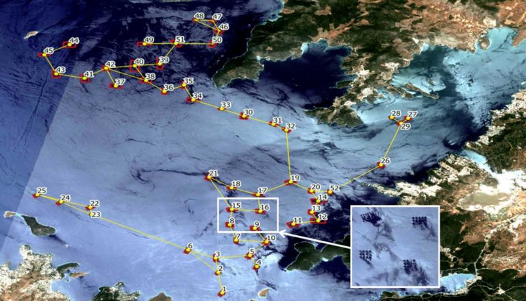
This service is used to quantify the proximity, density and connectivity of aquafarms within a region, and thereby helps coordinate Area Based Management (ABM). Using geospatial analytic tools such as Convex Hull Analysis and Nearest Neighbour Analysis, we are able to identify and determine farm networks. Neighbouring farms can achieve significantly improved results when coordinating management of diseases and biosecurity measures, in addition to the optimal use of resources and minimal use of chemicals and antibiotics. For accreditation bodies, a uniform index can be developed to serve as an indicator of ecological load.
Algal Bloom Detection
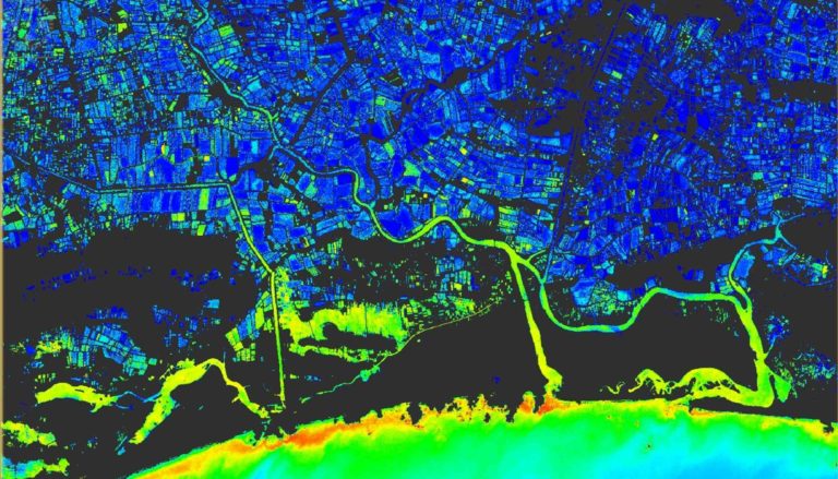
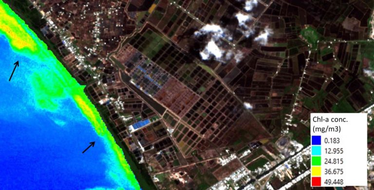
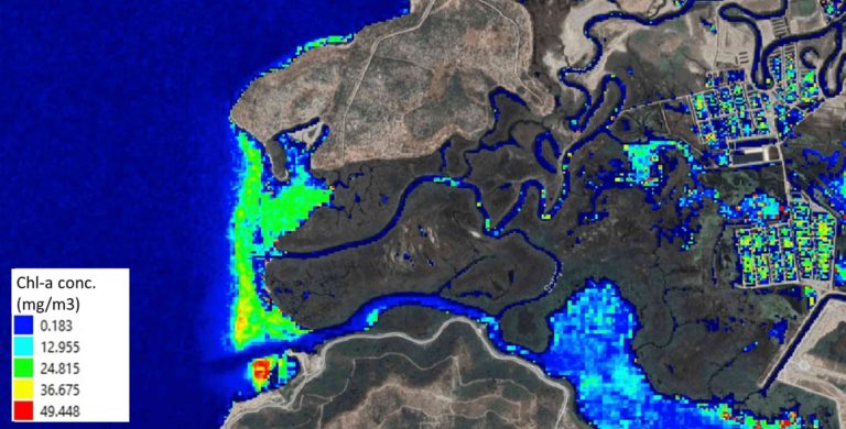
This service is used to identify eutrophication zones and provide early warning for the onset of Harmful Algal Blooms (HABs). HABs occur when colonies of algae grow out of control and produce toxic or harmful effects. This can lead to fish mortality, ecological degradation and human food poisoning through the consumption of fish. Using satellite data we detect algal blooms and measure Chlorophyll-a (Chl-a) concentrations. HABs are detected on the basis of Chl-a intensity and anomalies using recent historical data. An early warning system for the detection of HABs would allow aquafarms to take corrective action timely and help reduce fish mortality.
Land Use and Change Analysis
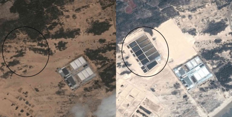
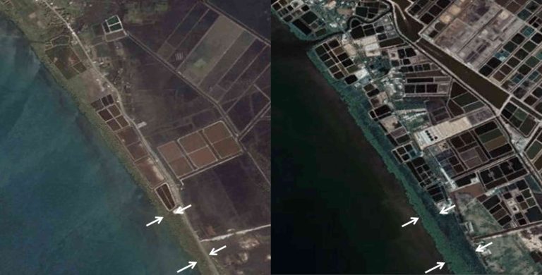
This service is used to assess land use and land cover changes in and around aquafarms over a period of time. It can be used to support environmental-impact analyses, by determining changes in land use or monitoring the rehabilitation efforts of ecosystems such as mangroves and wetlands. The service can also support social-impact analyses, by assessing land use and shared recourses, such as water bodies and coastal access with local communities. In addition, this service can check if aquafarms have adequate protection against extreme events, such as storms and floods, as well as risk from slow changing phenomenon, such as salt-water intrusion and coastal erosion.
Why use these services?
Lower Cost
Reduced need for on-site visits, as certification standards and farming operations can be assessed through remote sensing, thereby incurring significant cost savings.
Proactive
Several services offer early warnings, allowing farms to take proactive steps rather than being reactive to an adverse event.
Comprehensive
Complete spatial coverage provided as entire areas of interest are assessed.
Efficient
Assessments can be carried out more frequently and easily, including those located in remote or hard to access areas. In addition, several sites can be assessed in a single instance.
Long-Term Sustainability Vision
The services contribute directly towards the UN’s Sustainability Development Goal 14: “Life Below Water” and the European Green Deal ‘’Farm to Fork” strategy, creating a virtuous cycle for sustainability and good farming practices.
Dual-Value Proposition
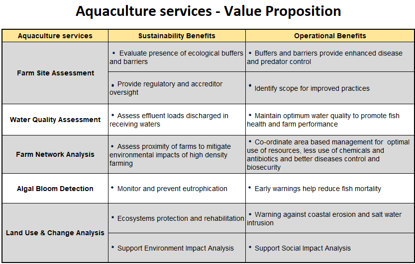
Each service contributes towards improving environmental sustainability as well as enhancing farming operations. Click here to see the dual benefits for each of our services.
Why use these services?
Lower Cost
Reduced need for on-site visits, as certification standards and farming operations can be assessed through remote sensing, thereby incurring significant cost savings.
Proactive
Several services offer early warnings, allowing farms to take proactive steps rather than being reactive to an adverse event.
Comprehensive
Complete spatial coverage provided as entire areas of interest are assessed.
Efficient
Assessments can be carried out more frequently and easily, including those located in remote or hard to access areas. In addition, several sites can be assessed in a single instance.
Long-Term Sustainability Vision
The services contribute directly towards the UN’s Sustainability Development Goal 14: “Life Below Water” and the European Green Deal ‘’Farm to Fork” strategy, creating a virtuous cycle for sustainability and good farming practices.
Dual Value Proposition
Each service contributes towards improving environmental sustainability as well as enhancing farming operations. Click here to see the dual benefits for each of our services.
FAQs
The quantitative measure for the water quality parameters is as follows: TSS (g/m3), Chl-a (mg/m3), CDOM (/m) and turbidity (m). In terms of limits of detection, the water quality parameters (TSS, Chl-a, CDOM) can be calculated up to light penetration depth of 90% of the water column.
The solutions use satellite remote sensing without any requirement for on-ground infrastructure and tools or in-person visits. Satellite derived insights can be provided in the form of georeferenced images (e.g. GeoTIFFs) and quantifiable data in tabular format along with GPS co-ordinates, and/or in a detailed report using graphs and time series analysis, as best suited to meet the customer’s needs.
Aquafarms larger than 100 square meters (with a minimum 10 metres length / width) can be assessed.
During periods of cloud cover over an area of interest, we are unable to assess water quality (as the readings are based on the water’s inherent optical properties), however, this is usually mitigated by the frequency of satellite over passes. A cloud filter is used during processing. All services come with quality guarantee (if we are unable to supply a reading, no money is charged for that reading).
Yes, our services can be tailor made to meet specific client needs and requirements. We strive to provide our clients with valuable insights to enable better decision making. Please get in touch – we will assess your needs and will make every effort to find a solution.
Contact Us
Disclaimer: Satellite remotely sensed data are generally recorded under changing environmental conditions, which might impact the accuracy of output data. Although results are based on well-established methods and tools are thoroughly validated for accuracy, remotely sensed data are subject to natural variations of the atmosphere, local conditions etc., therefore Satsense Solutions Limited cannot take any responsibility caused by the usage and interpretation of remote sensing products. As with all measuring tools / systems, calibration based on in-situ data is recommended.