Managing sedimentation to improve longevity and efficiency
Sedimentation poses the greatest threat to the sustainability of hydropower plants, reservoirs and rivers by reducing storage capacity, decreasing discharge capabilities and damaging turbines and other hydro-mechanical equipment. Sediment imbalances can also cause adverse ecological effects, such as accelerated eutrophication, loss of habitat and erosion.
Satsense Solutions uses satellite remote sensing technology and geospatial analytics to assess sedimentation in order to increase efficiency in hydropower generation and allow for better management of natural resources.
What is Sediment Assessment?
Satsense Solutions uses multispectral satellite data to quantify sediment concentrations (g/m3) at intake and outflow points of hydropower plants and in reservoirs and rivers. The assessment is used to identify high erosion areas, develop and validate sediment rating curves, determine trap efficiency, measure sediment distribution and yields, evaluate seasonal trends and variations and facilitate suitable sediment management practices.
The assessment is performed at high spatial and temporal resolutions, providing accurate, comprehensive and actionable insights. The solution offers vital information on environmental parameters critical for the sustainability of water and energy resources that would otherwise not be possible using conventional methods.
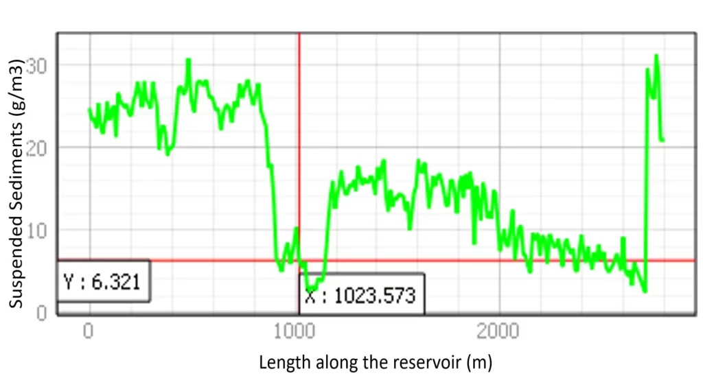
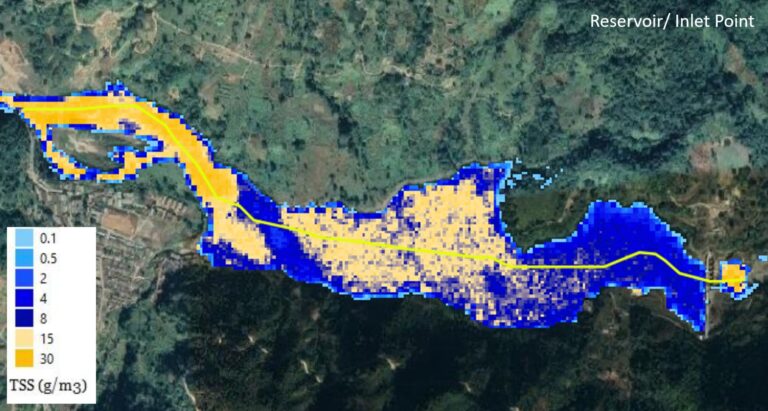
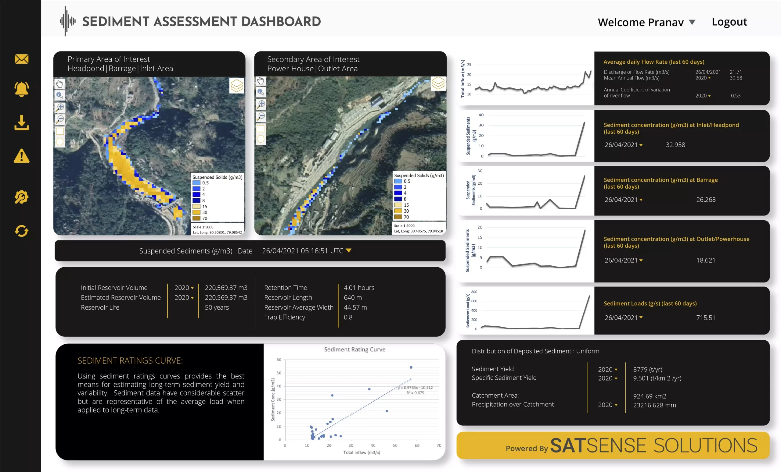
Suspended sediment concentration within reservoir
Graph of sediment concentration variability along the length of the reservoir
Suspended sediment concentrations (g/m3) in Run-of-River hydropower plant at Barrage (intake point)
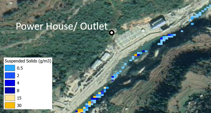
Suspended sediment concentrations (g/m3) in Run-of-River hydropower plant at Power House (outflow point)
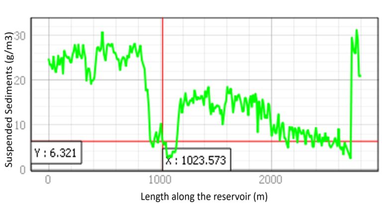
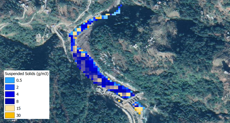
Suspended sediment concentration within reservoir
Graph of sediment concentration variability along the length of the reservoir
Suspended sediment concentrations (g/m3) in Run-of-River hydropower plant at Barrage (intake point)
Suspended sediment concentrations (g/m3) in Run-of-River hydropower plant at Power House (outflow point)
Play Video
How is the service provided?
Sedimentation is remotely sensed without the need for on-ground infrastructure and tools or in-person visits. Satellite derived insights can be provided in the form of georeferenced images (e.g. GeoTIFFs) and quantifiable data in tabular format along with GPS co-ordinates, and/or in a detailed report using graphs and time series analysis, as best suited to meet the customer’s needs.
The Sediment Assessment results can also be shared using an intuitive web-based dashboard, allowing users to visualise and download graphs, as well as combine in-situ data for better sediment management.
Who can use Sediment Assessment?
Hydropower Companies
To mitigate sedimentation risk at Run-of-River and Storage power plants and ensure efficient energy generation.
Reservoir Managers
To ensure better management of natural resources, used for drinking water, fishing, and recreational activities.
Governmental Bodies
To ensure ecological balance is being maintained without adverse effects, such as accelerated eutrophication, loss of habitat and erosion.
Contact Us
Disclaimer: Satellite remotely sensed data are generally recorded under changing environmental conditions, which might impact the accuracy of output data. Although results are based on well-established methods and tools are thoroughly validated for accuracy, remotely sensed data are subject to natural variations of the atmosphere, local conditions etc., therefore Satsense Solutions Limited cannot take any responsibility caused by the usage and interpretation of remote sensing products. As with all measuring tools / systems, calibration based on in-situ data is recommended.